1 books for « vadianus joachim »Edit
-
Topics
Sciences (1)
Travel (1)
-
Syndicate
ILAB (1)
SLAM (1)
EPITOME TRIUM TERRAE PARTIUM, ASIAE, AFRICAE ET EUROPAE.
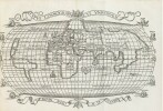
Zurich, Christoph Froschauer, 1534. In-folio de 6 ff., 273 pp., 1 p. et 14 ff. ; une carte dépliante. Demi-peau de truie sur ais de bois. Reliure du siècle dernier. 272 x 180 mm. FIRST EDITION of Vadianus’s influential description of the world, with the very important map of the world depicting America for almost the first time, showing the complete outline of South America and according to Sabin « lacking in most of the copies located ». Alden & Landis 534/31; Harrisse, BAV 189 ; JCB I, p, 460 ; Karrow 58/47.1 ; Sabin 98279 (erroneously dated 1533) ; Shirley 70 ; VD 16, V20. The map is a reduced size copy of the world map attributed to Sebastian Munster published in Grynaeus's Novis orbis regionum ac insularum veteribus incognitarum (Basel, 1532) itself primarily based on Waldseemüller's map of 1507.Vadianus describes all the continents, seas and islands, regions, mountains and towns of the world, with separate chapters on Europe, Africa, Asia, Palestine and even Paradise, offering a geographical reading of biblical history, The description of America can be found on pp. 263-273, In the same year an octavo edition was published (without the map), later followed by several other editions. Very good copy. Joachim Vadian (1484-1551), de son nom de naissance von Watt, fut un universitaire humaniste et réformiste de Saint-Gall qui, après une carrière dans la médecine à l'étranger, revient dans sa ville d'origine et participa activement à la vie politique de celle-ci en se faisant élire au sein du Petit Conseil puis en assurant le rôle de Bourgmestre. Il défendit les idées de la Réforme et produisit des travaux sur l'histoire qui firent autorité en son temps. Ex-libris manuscrit ancien de Joann Hueber et ceux de Harrison D. Horblit et celui de B. Mendel qui furent chacun d'importants bibliophiles et collectionneurs américains d'ouvrages scientifiques portant notamment sur les grandes navigations et la découverte de l'Amérique. TRES BEL EXEMPLAIRE COMPLET DE LA MAPPEMONDE tirée Typus cosmographique universalis proposant une projection ovale du monde avec la mention « America » notée pour l’actuelle Amérique du sud tandis que le nord y est nommé « terras de cuba ».
 Write to the booksellers


