 Write to the booksellers
12 books for « tofino de san miguel ... »Edit
-
Type
Book (8)
Maps (4)
-
Century
18th (9)
19th (2)
-
Topics
Atlas (1)
Cap (1)
Geography (1)
Maps (4)
Mediterranean sea (1)
Portugal (4)
Travel (1)
-
Countries
Denmark (7)
France (5)
-
Syndicate
ILAB (12)
SLAM (5)
Tofiño de San Miguel (Vicente) / Rédigé pour le reste par L. S. BAUDIN
Reference : 11405
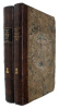
Manuel du Pilote de la Mer Méditerranée, ou Description des côtes d'Espagne, de France, d'Italie et d'Afrique dans la Méditerranée, depuis le détroit de Gibraltar jusqu'au Cap Bon pour l'Afrique, et jusqu'en dehors du détroit de Messine pour l'Europe. Traduit, Pour la Côte d'Espagne et la partie correspondante de la Côte de Barbarie, Du Derrotero ou Routier Espagnol de Tofino ;
Toulon, L. Laurent, Libraire-Editeur, 1828. In-8 relié demi-basane, 552 p. : 549 p. + Errrata - Table. Préface. Côte d'Europe - Iles Baléares - Côte d'Afrique - Côte d'Europe. Bon état : mouillure discrète en haut des premières pages, coins supérieur des 2 dernières pages manquant (ne concerne pas le texte) - coiffes présentes mais frottées.Première édition française pour cette traduction de l' Atlas marino de España, islas Azores y adyacentes (1765-1788).
Derrotero de las Costas de Espana en el Oceano Atlantico, y de las Islas Azores o Terceras para Inteligencia y uso de las Cartas Esféricas presentadas por el... Baylio fr. Don Antonio Valdes... y construidas de Orden de S.M. por... Don Vicente Tofino ...
Madrid, Hijos y Compania, 1789. 4to. Contemp. full mottled calf. Gilt spine. Titlelabel with gilt lettering. broad gilt borders on covers. Edges on covers gilt. Very light wear at corners. Stamps on title-page. (2),247 pp. Wide-margined, clean and fine, on good paper.
First edition of Tofino's famous Spanish pilot. ""Pilot's Log-book of the Coasts of Spain in the Atlantic Ocean and of the Azores, for the use of naval intelligence and nautical charts"".
Derrotero de las Costas de Espana en el Mediterraneo, y su correspondiente de Africa para inteligencia y uso de las Cartas Esféricas presentadas por el... Baylio fr. Don Antonio Valdes... y construidas de Orden de S.M. por... Don Vicente Tofino de sa...
Madrid, Hijos y Compania, 1789. 4to. Contemp. full mottled calf. Gilt spine. Titlelabel with gilt lettering. Broad gilt borders on covers. Edges on covers gilt. Stamps on title-page. (6),LVIII,(2),227 pp. Wide-margined, clean and fine, on good paper.
First edition of Tofino's famous Spanish pilot. ""Pilot's Log-book of the Coasts of Spain and... the Mediterranean.. for the use of naval intelligence and nautical charts"".
Descripciones de las Islas Pithiusas y Baleares.
Madrid, De Orden Superior, 1787. 4to. Contemp. full mottled calf. Raised bands. Gilt spine. Gilt borders on covers. Titlelabel with gilt lettering. Small crack in joint at upper compartment. Stamps on title-page. (2),158 pp., 3 folded tables. Clean and fine, wide-margined and printed on good paper.

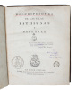
Scarce first edition.
[PAYS BASQUE] Anse et barre de Bilbao d'après le plan levé en 1789 par Don Vicente Tofiño. 1793.
1793. 367 x 523mm.
Beau plan du port de Bilbao, publié en 1793 par le Dépôt des Cartes et Plans de la Marine d'après le plan levé en 1789 par Tofiño de San Miguel. Le nord est situé au bas de la carte. Astronome espagnol originaire de Galice, Tofiño de San Miguel entra très tôt dans la Marine. En 1770, il fut nommé professeur de l'Académie des Gardes Marines. La Guerre d'Indépendance en Amérique ayant convaincu Charles III d'Espagne de la nécessité d'augmenter sa marine et d'encourager les progrès de la navigation, il chargea en 1783 Tofiño de San Miguel de parcourir les côtes d'Espagne. Son Atlas maritimo de España fut l'une des publications cartographiques espagnoles les plus importantes, à la base de la cartographie moderne espagnole. Bel exemplaire.
![[PAYS BASQUE] Anse et barre de Bilbao d'après le plan levé en 1789 par Don Vicente Tofiño. 1793.. TOFIÑO de SAN MIGUEL (Don Vicente).](https://static.livre-rare-book.com/pictures/LBW/lbw-1807_2.jpg)
![[PAYS BASQUE] Anse et barre de Bilbao d'après le plan levé en 1789 par Don Vicente Tofiño. 1793.. TOFIÑO de SAN MIGUEL (Don Vicente).](https://static.livre-rare-book.com/pictures/LBW/lbw-1807_2_thumb.jpg)
[PAYS BASQUE] Port de Santander d'après le plan levé par Tofiño. 1793.
1793. 372 x 526 mm.
Très beau plan figurant le port de Santander, publié en 1793 par le Dépôt des Cartes et Plans de la Marine d'après le plan levé par Tofiño de San Miguel. Le nord est situé au bas de la carte. Astronome espagnol originaire de Galice, Tofiño de San Miguel entra très tôt dans la Marine. En 1770, il fut nommé professeur de l'Académie des Gardes Marines. La Guerre d'Indépendance en Amérique ayant convaincu Charles III d'Espagne de la nécessité d'augmenter sa marine et d'encourager les progrès de la navigation, il chargea en 1783 Tofiño de San Miguel de parcourir les côtes d'Espagne. Son Atlas maritimo de España fut l'une des publications cartographiques espagnoles les plus importantes, à la base de la cartographie moderne espagnole. Bel exemplaire.
![[PAYS BASQUE] Port de Santander d'après le plan levé par Tofiño. 1793.. TOFIÑO de SAN MIGUEL (Don Vicente).](https://static.livre-rare-book.com/pictures/LBW/lbw-1804_2.jpg)
![[PAYS BASQUE] Port de Santander d'après le plan levé par Tofiño. 1793.. TOFIÑO de SAN MIGUEL (Don Vicente).](https://static.livre-rare-book.com/pictures/LBW/lbw-1804_2_thumb.jpg)
[PAYS BASQUE] Port du Passage d'après le plan levé en 1788 par Tofiño. 1793.
1793. 369 x 525 mm.
Beau plan figurant le port de Pasaia, publié en 1793 par le Dépôt des Cartes et Plans de la Marine d'après le plan levé en 1788 par Tofiño de San Miguel. Le nord est situé à droite de la carte. Astronome espagnol originaire de Galice, Tofiño de San Miguel entra très tôt dans la Marine. En 1770, il fut nommé professeur de l'Académie des Gardes Marines. La Guerre d'Indépendance en Amérique ayant convaincu Charles III d'Espagne de la nécessité d'augmenter sa marine et d'encourager les progrès de la navigation, il chargea en 1783 Tofiño de San Miguel de parcourir les côtes d'Espagne. Son Atlas maritimo de España fut l'une des publications cartographiques espagnoles les plus importantes, à la base de la cartographie moderne espagnole. Bel exemplaire.
![[PAYS BASQUE] Port du Passage d'après le plan levé en 1788 par Tofiño. 1793.. TOFIÑO de SAN MIGUEL (Don Vicente).](https://static.livre-rare-book.com/pictures/LBW/lbw-1806_2.jpg)
![[PAYS BASQUE] Port du Passage d'après le plan levé en 1788 par Tofiño. 1793.. TOFIÑO de SAN MIGUEL (Don Vicente).](https://static.livre-rare-book.com/pictures/LBW/lbw-1806_2_thumb.jpg)
[PAYS BASQUE] Port de Santoña d'après le plan levé en 1789 par Tofiño. 1793.
1793. 372 x 527 mm.
Très beau plan figurant le port de Santoña, dans la communauté autonome de Cantabrie. Il a été publié en 1793 par le Dépôt des Cartes et Plans de la Marine d'après le plan levé en 1789 par Tofiño de San Miguel. Le nord est situé à droite de la carte. Astronome espagnol originaire de Galice, Tofiño de San Miguel entra très tôt dans la Marine. En 1770, il fut nommé professeur de l'Académie des Gardes Marines. La Guerre d'Indépendance en Amérique ayant convaincu Charles III d'Espagne de la nécessité d'augmenter sa marine et d'encourager les progrès de la navigation, il chargea en 1783 Tofiño de San Miguel de parcourir les côtes d'Espagne. Son Atlas maritimo de España fut l'une des publications cartographiques espagnoles les plus importantes, à la base de la cartographie moderne espagnole. Bel exemplaire.
![[PAYS BASQUE] Port de Santoña d'après le plan levé en 1789 par Tofiño. 1793.. TOFIÑO de SAN MIGUEL (Don Vicente).](https://static.livre-rare-book.com/pictures/LBW/lbw-1803_2.jpg)
![[PAYS BASQUE] Port de Santoña d'après le plan levé en 1789 par Tofiño. 1793.. TOFIÑO de SAN MIGUEL (Don Vicente).](https://static.livre-rare-book.com/pictures/LBW/lbw-1803_2_thumb.jpg)
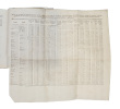
Derrotero de las Costas de Espana en el Mediterráneo y su Correspondiente de Africa. Ecrito en los Anos de 1783 y 1784 por el Brigadier de la Real Armada. Segunda Edicion, corregida y adicionada por la Real Direccion de Hidrografia.
Madrid, Imprenta Real, 1832. Small 4to. Near contemp. hcalf. Gilt spine and with gilt lettering. Stamp on title-page. LX,243 pp. Clean and fine, printed on good paper.
Second edition of Tofino's importent Log-Book, first published 1787. (Pilot's Log-book of the Coasts of Spain in the Mediterranean Sea and Africa). ""Vincente Tofiño was a rear-admiral in the Spanish navy. He was a renowned astronomer and mathematician and near the close of his career was the King’s hydrographer. Between 1783-1788, Tofiño charted the ports and coasts of Spain as well as the shore of North Africa. He eventually was elected as correspondent of the Spanish Academy of History and of the French and Portuguese Academies of Sciences."" WITHBOUND: Don Josef Luyando. Memoria en que se Manifiestan las Operaciones practicadas para lavantar fundamentalmente La carta del Estrecho de Gibraltar. Madrid, Impenta Real, 1826. - 39,(1-errata) pp.
"SAN MIGUEL, DON VICENTE TOFINO DE. (+) [translated and written by:] POUL DE LÖWENÖRN.
Reference : 58844
(1792)
Beskrivelse over den Spanske Kyst i Middelhavet og den Deel af Kysten af Afrika beliggende lige overfor til Oplysning og Brug ved de derover efter den Kongelige Befaling i Spanien [i.e. English: ""Description of the Spanish Mediterranean coast and the...
[No place], 1792 & 1793. Folio. 2 volumes. Vol. 1 (1792) in a bit later half calf with five rasied bands and gilt lettering to spine. Vol. 2 in a later full sprinkled calf with five raised bands and with gilt lettering and gilt stamp to spine. Small paper-label pasted on to pasted down front end-papers and stamp to first front free end-paper and two stamps to title-pages. Light wear to extremities. Written of thick paper. Fine and clean. LLII, 277, (3) pp. XVII, 291, (4) pp.

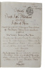
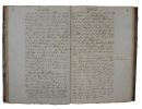
Danish manuscript translation of Tofino's famous description of the Spanish Mediterranean coast. ""Vincente Tofiño was a rear-admiral in the Spanish navy. He was a renowned astronomer and mathematician and near the close of his career was the King’s hydrographer. Between 1783-1788, Tofiño charted the ports and coasts of Spain as well as the shore of North Africa. He eventually was elected as correspondent of the Spanish Academy of History and of the French and Portuguese Academies of Sciences."" Translator De Løwenørn (Kommandør-Kaptajn Friderich de Løwenørn) n 1784, captain lieutenant Poul de Løwenørn assisted the Danish crown in establishing the Royal Danish Nautical Chart Archive. He was appointed the institution’s first Director. At this time, only France had a similar institute.""In the first instance, the Danish Admirality requested Løwenørn to collect all existing nautical charts and navigational details in the country, for both Danish and international waters. He was to develop accurate and reliable charts for both the Navy and Merchant Marine.In addition to these formidable tasks, Løwenørn also took the initiative to establish a Lighthouse Authority, a Buoy Authority and a Pilot Authority as well as improve the country’s harbours."" (Danish Geodata Agency).Hansen, Sources of the History of North Africa, Asia and Oceania in Denmark, p. 459.
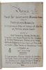
"SAN MIGUEL, DON VICENTE TOFINO DE. (+) [translated and written by:] POUL DE LÖWENÖRN.
Reference : 58880
(1792)
Beskrivelse over den Spanske Kyst i Middelhavet og den Deel af Kysten af Afrika beliggende lige overfor til Oplysning og Brug ved de derover efter den Kongelige Befaling i Spanien [i.e. English: ""Description of the Spanish Mediterranean coast and the...
[No place], 1792 & 1802. Folio. 2 volumes uniformly bound in contemporary half calf with five raised bands and with gilt lettering and gilt stamp to spine. Small paper-label pasted on to pasted down front end-papers and stamp to first front free end-paper and two stamps to title-pages. Light wear to extremities. Written of thick paper. Fine and clean. LLXIII, (1), 307, (4) pp."" 15, (6), 344, (4) pp
Danish manuscript translation of Tofino's famous description of the Spanish Mediterranean coast. ""Vincente Tofiño was a rear-admiral in the Spanish navy. He was a renowned astronomer and mathematician and near the close of his career was the King’s hydrographer. Between 1783-1788, Tofiño charted the ports and coasts of Spain as well as the shore of North Africa. He eventually was elected as correspondent of the Spanish Academy of History and of the French and Portuguese Academies of Sciences."" Translator De Løwenørn (Kommandør-Kaptajn Friderich de Løwenørn) n 1784, captain lieutenant Poul de Løwenørn assisted the Danish crown in establishing the Royal Danish Nautical Chart Archive. He was appointed the institution’s first Director. At this time, only France had a similar institute.""In the first instance, the Danish Admirality requested Løwenørn to collect all existing nautical charts and navigational details in the country, for both Danish and international waters. He was to develop accurate and reliable charts for both the Navy and Merchant Marine.In addition to these formidable tasks, Løwenørn also took the initiative to establish a Lighthouse Authority, a Buoy Authority and a Pilot Authority as well as improve the country’s harbours."" (Danish Geodata Agency).Hansen, Sources of the History of North Africa, Asia and Oceania in Denmark, p. 459.
"SAN MIGUEL, DON VICENTE TOFINO DE. (+) [translated and written by:] POUL DE LÖWENÖRN.
Reference : 59255
(1802)
Beskrivelse over den deel af den Spanske Kyst liggende imod det Atlantiske Ocean tillige med Beskrivelse over de Azoriske Øer [i.e. English: ""Pilot's Log-book of the Coasts of Spain in the Atlantic Ocean and of the Azores""].
[No place], 1802. Folio. In contemporary half calf with five raised bands. Wear to extremities and paper labels pasted on to pasted down front free end-paper. Stamp to title-page. Written of thick paper. XVII, 291, (4) pp.

Danish manuscript translation of Tofino's famous description of the Spanish and Portuguese coast towards the Atlantic Ocean. ""Vincente Tofiño was a rear-admiral in the Spanish navy. He was a renowned astronomer and mathematician and near the close of his career was the King’s hydrographer. Between 1783-1788, Tofiño charted the ports and coasts of Spain as well as the shore of North Africa. He eventually was elected as correspondent of the Spanish Academy of History and of the French and Portuguese Academies of Sciences."" Translator De Løwenørn (Kommandør-Kaptajn Friderich de Løwenørn) n 1784, captain lieutenant Poul de Løwenørn assisted the Danish crown in establishing the Royal Danish Nautical Chart Archive. He was appointed the institution’s first Director. At this time, only France had a similar institute.""In the first instance, the Danish Admirality requested Løwenørn to collect all existing nautical charts and navigational details in the country, for both Danish and international waters. He was to develop accurate and reliable charts for both the Navy and Merchant Marine.In addition to these formidable tasks, Løwenørn also took the initiative to establish a Lighthouse Authority, a Buoy Authority and a Pilot Authority as well as improve the country’s harbours."" (Danish Geodata Agency).Hansen, Sources of the History of North Africa, Asia and Oceania in Denmark, p. 459.