Write to the booksellers
2 books for « munster sebastian 148... »Edit
-
Topics
Geneva (1)
Helvética (1)
Travel (1)
-
Countries
France (1)
Switzerland (1)
-
Syndicate
ILAB (1)
NVVA (1)
SLACES (1)
Double page (p. 98/99) woodcut view of Geneva from Sebastian Münster's famous "Cosmographia". Civitas Genevensis apud allobroges populos... " Clarissiniæ civitatis Genevensis situs & figuratio, latusque eius meridianum..
Basileae Henricum Petri, 1552, 15.5x35.5 cm (Vue), original Handcolored copy; Latin title to verso / Vue de Genève gravés sur bois, sur 2 feuilles, coloriés d’époque, Feuille N° 98/99. 1 feuille 32x40 cm.
The woodcut view shows the city from across Lake Geneva/ Lac Léman with the covered bridge joining the two parts of the city.Coat of arms to upper left corner ; text below. Good dark impression; minor show through of text from verso; small hole to upper and lower margin from binding; light spotting to centre of view & light damp stain to lower blank margin, below text; lower centre fold split, repaired to verso; old ink under linings and corrections to text image disp.
(SLACES, NVVA)
Phone number : 41 (0)26 3223808
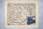
POLONIAE ET UNGARIAE TABULA.
CIRCA 1540-1560. BELLE CARTE GEOGRAPHIQUE (34,5 X 27 CENTIMETRES ENVIRON, 32,5 X 41 AVEC LES MARGES) DE LA POLOGNE ET DE LA HONGRIE, GRAVEE SUR BOIS ET COLORIEE A LA MAIN D'EPOQUE. PROVIENT DE LA VERSION PAR MUNSTER DE LA "GEOGRAPHIA UNIVERSALIS" D'APRES PTOLEMEE, QUI CONNUT PLUSIEURS EDITIONS EN PLUSIEURS LANGUES ENTRE 1540 ET 1560, CELLE-CI AVEC LE TEXTE LATIN AU DOS ET PORTANT LE NUMERO 16. TRES BEL ETAT.