 Write to the booksellers
10 books for « mercator gerhard »Edit
-
Type
Book (9)
Maps (1)
-
Language
French (9)
Latin (1)
-
Century
16th (4)
21st (1)
-
Topics
Atlas (1)
Basel (1)
Cartography (1)
Engraving (books about) (3)
Geneva (2)
Helvética (7)
Maps (1)
Switzerland (4)
Travel (1)
Zurich (1)
-
Countries
Denmark (1)
Greece (1)
Switzerland (8)
-
Syndicate
ILAB (10)
NVVA (4)
SLACES (4)
(Argow, ohne Titelkartusche). Per Gerardum Mercatorem. Cum privilegio. (unten links). (Ca. 1:340 000).
(Duisburg, o. Dr., 1585). Gestochene kolorierte Karte (34x45 cm).
Ryhiner 3201:21. - Aus 'Galliae tabule geographicae' von Gerard Mercator, 'Helvetia antiqua', Text verso (Bl. q): Argovv. - Verso mit hinterlegtem Einriss unten im Falz.
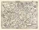
Das Wiflispvrgergov (Titelkartusche oben links). Per Gerardum Mercatore(m). Cum privilegio (unten rechts). (Ca. 1:340 000).
(Duisburg, o. Dr., 1585). Gestochene kolorierte Karte (34x45 cm).
Ryhiner 3201:29. - Aus 'Galliae tabule geographicae' von Gerard Mercator, 'Helvetia antiqua', Text verso (Bl. P): VViflispvrgergovv. - Verso mit hinterlegtem Einriss unten im Falz.
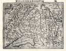
Zurichgow, ohne Titelkartusche). Per Gerardum Mercatorem. Cum privilegio. (unten links). (Ca. 1:340 000).
(Duisburg, o. Dr., 1585). Gestochene kolorierte Karte (34x45 cm).
Ryhiner 3201:12. - Aus 'Galliae tabule geographicae' von Gerard Mercator, 'Helvetia antiqua', Text verso (Bl. O): Zvrichgovv, et Basiliensis provincia. - Verso mit hinterlegtem Einriss unten im Falz.
Atlas sive cosmographicae meditationes de fabrica mundi et fabricati figura.
Faks. der Ausg. Duisburg 1595. Berlin, Coron bei Kindler Verlag. 2010. (260) S. mit zahlreichen farbigen Landkarten, 31 S. Erklärungen. Illustrierter Lederband.
Faksimile-Ausgabe des Exemplars der Fürstlich Fürstenbergischen Hofbibliothek Donaueschingen.
Argovia / Argou. Kantons-Karte v. Aargau.
Vers 1600, 14 x 19 cm, carte gravée, texte latin au verso, 1 feuille (17 x 21.5 cm).
Blumer 72. Image disp.
(SLACES, NVVA)
Phone number : 41 (0)26 3223808
Lacus Lemannus. - Lac de Genève.
Vers 1600, 14 x 19.5 cm, carte gravée. N° sur la feuille 287 1 feuille (17 x 21.5 cm).
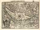
Image disp.
(SLACES, NVVA)
Phone number : 41 (0)26 3223808
Das Wiflispurgergou. - Canton de Fribourg et Vaud.
Vers 1600, 14 x 19 cm, petite carte gravée, 1 feuille (17 x 21.5 cm).
Blumer 72. Image disp.
(SLACES, NVVA)
Phone number : 41 (0)26 3223808
MOREA - PELOPONNESUS
Amsterdam, Joannes Janssonius, circa 1640. Double page copper map 59 x 51, printed surface 41 x 34.
Phone number : 00 30 210 3616330
Helvetia cum finitimis regionibus confoederatis. Carte gravée.
(Amsterdam, Hondius), (um 1630- 1645), 34x45 cm (Carte), Kolorierter Schweizer Karte in Kupferdruck / carte gravée sur cuivre coloriée, verso texte en neerlandais: Switserlandt, sous Passepartout
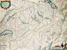
Ursprungswerk: Gerardi Mercatoris atlas sive cosmographicae meditationes de fabrica mundi et fabricati figura hrsg v. H. Hondius (Amsterdam 1630). Koloriert. Sammlung Ryhiner collection Bd. 2, n° 6046; Koeman III, map 4900: 2, ed. 2:611 (1663ff. French); Image disp.
(SLACES, NVVA)
Phone number : 41 (0)26 3223808
Iutia Septentrionalis.
(Amsterdam, 1595-1623). 29x40 cm. Kobberstukket kort over Nørrejylland, egnene omkring Limfjorden, vendsyssel i nord og til Horsens i syd samt Samsø. Samtidig håndkolorering. Bagsiden med latinsk tekst. Barokkartouche.
Den lidt løjerlige gengivelse af Djursland går igen på samtlige Danmarkskort i de næste 50 år.Bramsen p. 64, hvor kortet er gengivet.- Nørlund 39.