1 books for « isles de la sonde ca... »Edit
-
Topics
Borneo (1)
Java (1)
Sumatra (1)
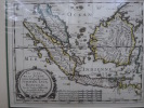
Les Isles de la Sonde entre lesquelles sont Sumatra, Java, Bornéo, par le Sr Sanson d'Abbeville, Géographe du Roy, avec privilège pour 10 ans, 1652.
Paris, Ca. 1650. 1 carte en couleurs des Isles de la Sonde, de format 26*21 cm ($0*31 cm sous marie-louise, parfait état.
Copper engraved double page, hand colored in outline, with decorative cartouche. Covers Indonesia and the area from the Malay Peninsula and Borneo in the north to Java and the Sonda Straits in the south. Showing boundaries, major cities, towns, villages, rivers, mountains, drainage, etc. Relief shown pictorially.
 Write to the booksellers

