 Write to the booksellers
THE NATIONAL GEOGRAPHIC MAGAZINE.
The World map.
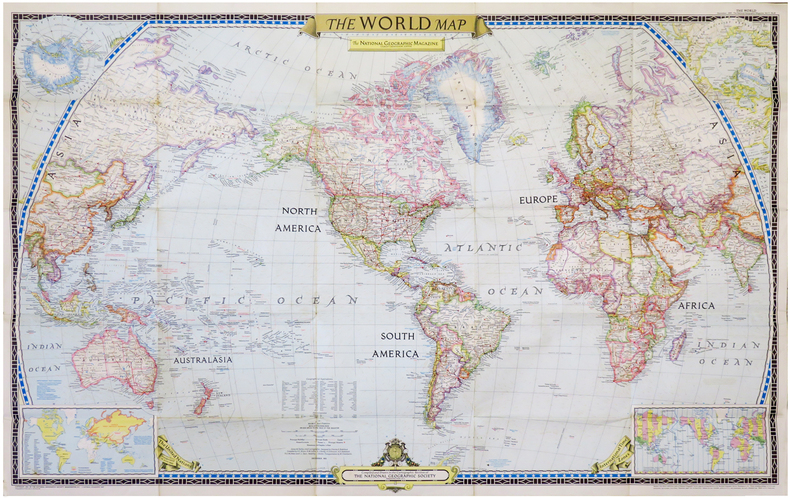
Washington, D.C., The National Geographic Magazine, 1951. 0,65 x 1,02 m.
Reference : LBW-6834
Grande carte du monde, dessinée par le département cartographie du National Geographic Magazine, et lithographiée en couleurs par A.Hoen and Co. à Baltimore, sous la direction de Gilbert Hovey Grosvenor, premier rédacteur en chef à temps plein du National Geographic, et considéré comme le père du photojournalisme. La carte a été publiée comme supplément au n°6 de décembre 1951. En carton : carte de l'Antarctique ; carte de l'Arctique ; carte du monde montrant les pays membres des Nations Unies (en jaune), les pays membres de l'OTAN (une note indique que la Grèce et la Turquie ont été invitées à rejoindre l'Organisation le 20 septembre 1951), et les limites des pays communistes ; carte du monde montrant les fuseaux horaires. En bas et au centre, figure le logo de la National Geographic Society, fondée en 1888. Bon exemplaire, replié.
Bookseller's contact details
Librairie Le Bail
Didier Le Bail
13 rue Frédéric Sauton
75005 Paris
France
33 01 43 29 72 59
Payment mode
Sale conditions
Conditions de vente conformes aux usages et aux règlements du Syndicat de la Librairie Ancienne et Moderne (SLAM) et de la Ligue Internationale de la Librairie Ancienne (LILA). Paiements acceptés : cartes bancaires, via un lien de paiement, chèques, virements Conditions of sale in accordance with the practices and regulations of the Syndicat de la Librairie Ancienne et Moderne (SLAM) and the International League of Antiquarian Booksellers (ILAB). Payments accepted: credit cards, via payment link, checks, and bank transfers.
5 book(s) with the same title
Reference : albfbcc8c8a25ca24b8
Yu. Suprunenkos Places of Power on the World Map. In Russian /Suprunenko Yu. Me
Yu. Suprunenkos Places of Power on the World Map. In Russian /Suprunenko Yu. Mesta sily na karte mira. Mysterious Places of the World (series) M Veche 2015. Contact us for details or to request photos of available books. Delivery of this book could take longer than normal due to additional handling time before shipping, and no rush delivery options are available. Please let us know if you have a specific date by which you need to receive your order. SKUalbfbcc8c8a25ca24b8
Visual sources book - A326 empire : 1492-1975- atlantic fragment from the world map of piri reis- alberto cantino planisphere, central mexico in the 16th century, cristobal de villalpando central square of mexcio city, dutch victory over te portuguese ...
THE OPEN UNIVERSITY. 2008. In-4. Broché. Etat d'usage, 2ème plat abîmé, Dos satisfaisant, Intérieur frais. 62 pages illustrées de reproductions et cartes couleurs. En anglais.. . . . Classification Dewey : 420-Langue anglaise. Anglo-saxon
Classification Dewey : 420-Langue anglaise. Anglo-saxon
THE WORLD MAP - THE NATIONAL GEOGRAPHIC MAGAZINE.
THE NATIONAL GEOGRAPHIC SOCIETY. 1951. In-Plano. Broché. Bon état, Couv. convenable, Dos satisfaisant, Intérieur frais. Carte dépliante en couleurs de DIMENSION : 73 x 106 cm environ.. . . . Classification Dewey : 912-Atlas, cartes et plans
2 PHOTOS DISPONIBLES. Classification Dewey : 912-Atlas, cartes et plans
Reference : albacaedd9b650df23f
Map of the World. Union of Soviet Socialist Republics. World map. Union Of Sovi
Map of the World. Union of Soviet Socialist Republics. World map. Union Of Soviet Socialist Republics. In Russian /Karta mira. Soyuz Sovetskikh Sotsialisticheskikh Respublik.World map. Union Of Soviet Socialist Republics. General Directorate of Geodesy and Cartography. 1982. 83 p. We have thousands of titles and often several copies of each title may be available. Please feel free to contact us for a detailed description of the copies available. SKUalbacaedd9b650df23f.
Carte du monde bi face Amerique nord sud et Europe Afrique,Asie, Australie texte en français -Large Map CHART OF THE WORLD STEAMER ROUTES
1910 Antique Double Sided World Map by The Scarborough Company c1910 Grande carte toilée double face pliée sous étui avec itineraires et distances.This map has Europe, Asia, Africa & Australia on one side and North America & South America on the other and was published by the Scarborough Company, London, England, around 1910 (latest copyright date) but was printed in Boston, Mass, USA and was originally priced at 15 shillings (£0.75)- quite a sum at that time - equivalent to about £80 now. It includes principal ocean steamship lines, distances in nautical miles along steamship routes andthe routes shown in red on the map, principal places etc. It measures 39 inches wide by 41 inches high (100 x 104 cm) and is printedon cloth. It's in reasonable condition for its age - a bit of foxing, a couple of other marks and some slight frayingbut no splits or tears- see pictures - they form part of the description.
Etui titré et decoré,bon etat,traces de mouillures en haut des plis et marge,dans l'etat Remise de 20% pour toutes commandes supérieures à 200 €