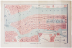
HAUSERMANN (Rémi).
[NEW YORK] Plan de New-York (États-Unis).
[1878]. 265 x 427 mm.
Reference : LBW-5011
Beau plan de Manhattan avec les rives de l'Hudson et de l'East River montrant Brooklyn, Jersey City et Hoboken, gravé en couleurs par le dessinateur-géographe Rémi Hausermann, pour le Bulletin de la Société de Géographie, dont l'un des rédacteurs fut Alexandre-François Barbié du Bocage. Le plan montre Governors Island avec Castle Williams et Fort Columbus, renommé Fort Jay en 1904, Ellis Island avec Fort Gibson, qui abritera les bâtiments du centre d'immigration à partir de 1892. Bel exemplaire, replié.
Bookseller's contact details
Librairie Le Bail
Didier Le Bail
13 rue Frédéric Sauton
75005 Paris
France
33 01 43 29 72 59
Payment mode


2 book(s) with the same title
Plan de New-York (Etats-Unis)
FAYARD. 1877. In-Folio. En feuillets. Bon état, Livré sans Couverture, Dos satisfaisant, Intérieur frais. Carte couleur en double-planches.. . . . Classification Dewey : 912-Atlas, cartes et plans
Provenant de l'Atlas Universel, contenant la Géographie physique, politique, historique, théorique, militaire, industrielle, agricole & commerciale du Monde avec la statistique la plus récente et la plus complète. Dressée par Vuillemin, Charles Lacoste, Monin et Clerot. Gravé sur acier par Lacouchy, Lorsignol et Haussermann. Classification Dewey : 912-Atlas, cartes et plans
Guide Franco-Américain, renfermant un RESUME GEOGRAPHIQUE DES ETATS-UNIS, LA LOI MILITAIRE, de nombreuses gravures, le Plan de la Ville de New York, et le nouveau tarif de douane et l' Annuaire de la Colonie de Langue Française de New York et des environs..
New York, 1911. In-8o, 736 p. Many illustrations -some colored- with details concerning accommodation, sightseeing, local services and merchants with their products. Large folded double sided map of the State and the City of New York -chromolithograpy-. A real mine of information at the beginning ot the XXth century with merchants index at the end.
 Write to the booksellers


