NEPTUNE FRANCOIS.
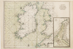
[IRLANDE] Carte générale des costes d'Irlande, et des costes occidentales d'Angleterre avec une partie de celles d'Ecosse.
[1693]. 607 x 868 mm.
Reference : LBW-2918
Magnifique et grande carte marine figurant l'Irlande et les côtes occidentales de l'Ecosse et de l'Angleterre entre Ayr et Plymouth, issue de la première édition du Neptune François, premier atlas français entièrement dédié à la marine, initié par Colbert, ministre et secrétaire d'Etat à la Marine sous Louis XIV. Y figurent les lignes de rhumbs marquant la direction des vents et deux roses des vents. En carton, carte détaillée de l'entrée de la rivière Dee entre Chester et Holt. Très rare exemplaire avec la mer entièrement aquarellée à l'époque. Bel exemplaire, rousseurs légères dans la partie inférieure de la carte. Pastoureau, NEPTUNE FRANCAIS A, 10.
Bookseller's contact details
Librairie Le Bail
Didier Le Bail
13 rue Frédéric Sauton
75005 Paris
France
33 01 43 29 72 59
Payment mode


1 book(s) with the same title
"(JAILLOT, A.H.) - SEA-CHART OF IRELAND AND ENGLAND FROM ""LE NEPTUNE FRANCOIS"".
Reference : 16114
(1693)
Carte Generale de Costes D'Irlande, et des Costes Occidentales D'Angleterre avec une Partie de celles D'Ecosse. H. van Loon sculp.
(No date, no place, (1693). Very large engraved seechart, measuring 60,5 x 85,5 cm. in original outline colouring with inset view of the River Dee at Chester. The chart showing the whole of Ireland and the Westcoast of England from Cornwall to Cuningham in the north. A fine impression on good thick paper, bearing the watermark: BYCOLUMBIER. Folded down the center.
The ""Neptune Francois"" was published in 1693, and its charts are larger and more lavishly decorated then those of any preceding book of its kind.This cart is without year, place and ""par ordre du Roi"", pointing to a later print, but issued from the original copperplate. It is also without ""Imprimerie Royale"" belonging to the most recent impression from 1792. Koeman IV,425:10.
 Write to the booksellers


