"ROSE, F. W.
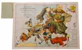
Angling in Troubled Waters Der Fischfang im Trüben - La Pêche en l'eau trouble - La Pesca nelle acque turbes. A Serio-Comic Map of Europe By Fred W. Rose. Author of the ""Octopus"" map of Europe.
London, Bacon & Co. Ltd., 1899. Chromlithographed folded map (50 x 71 cm) in original printed covers (20 x 14 cm). 5 cm tear in horisontal fold in left margin. 10 cm long tear in spine of cover, but map and wrappers still firmly attached, otherwise a fine copy.
Reference : 60074
A fine copy of Frederick Rose’s famous caricature map of Europe with each country depicted as an angler having various levels of success in catches colonies. Serving as an allegory for European colonial interference elsewhere, this type of map influenced and reflected popular opinion, much like a political cartoon. Political boundaries and power struggles define this work. The 19th-century “serio-comic map” caricaturizes each European country as a fisherman, holding a sack with its imperial catch, or about to lose what it has caught. Serving as an allegory for European colonial interference elsewhere, this type of “persuasive” map influenced and reflected popular opinion, much like a political cartoon. Despite the popularity of his posters and a considerable output, there has been some controversy regarding Frederick Rose’s exact identity, in part due to his common name. Recent research suggest that Rose was of honorable Scottish descent and spent most of his professional life working as a civil-servant at Somerset House in London (Inland Revenue at the time).
Bookseller's contact details
Herman H. J. Lynge & Son
William Schneider
Silkegade 11
1113 Copenhagen
Denmark
+45 33 155 335
Payment mode
Sale conditions
All items may be returned for a full refund for any reason within 14 days of receipt.
 Write to the booksellers


