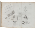
"OXHOLM, PETER LOTHARIUS.
De Danske Vestindiske Öers Tilstand i Henseende til Population, Cultur og Finance-Forfatning, i anledning af nogle breve fra St. Croix, indrykkede i det Politiske og Physiske Magazin for Marts og April Maaneder 1797, hvortil er föiet Beskrivelse om Su...
Kiöbenhavn, Schultz, 1797. 8vo. Uncut, partly unopened, in contemporary (original?) marbled boards. Part of spine missing and wrappers very loose. Internally with very light occassional brownspotting. 84 pp. + four folded plates, each with the accompanying ""Plan""-leaf (complete).
Reference : 58888
First edition of Oxholm's early and important work on the state of the West Indies in which he describes the government loans to planters to buy slaves in the ten years from 1792 until abolition of the trade in 1802 and the effects of British imports on the price and quality of slaves. ""Denmark acquired St. Croix from France in 1733. Oxholm was a young Danish officer sent to the Danish West Indies in 1778 to map all the fortifications in the islands, suggest improvements, and estimate their cost. He was also to create topographic maps of the islands of St. Thomas and St. John. He mapped only St. John, but presented numerous drawings and maps at the Danish court where his work was approved and rewarded. Having married into a St. Croix family, he returned there and became a sugar planter. In 1794 he privately published a detailed map of St. Croix that he had created."" (John Russell Bartlett Collection)""Lieutenant Oxholm was a promising young man of 24 when he was sent to the Danish possessions in The West Indies. Oxholm’s task was to examine the ability of the colony to defend itself against attack and draw new maps of St. Thomas and St. John. But Oxholm was an enterprising man and he also examined a number of issues that he had not been tasked to deal with at all. The political situation of the colony, conditions for soldiers and enslaved laborers, health care and conditions for prisoners and lepers, organization of the sugar trade and the schools were all described. Oxholm became an advocate of slavery that he believed was necessary for the economy of the colony. But he was critical of the miserable living conditions of enslaved laborers, soldiers, and the sick.Oxholm’s maps were of high quality and impressively accurate. Some have been in use almost up until the present day. Today, his maps and drawings are considered by the Danish Ministry of Culture to be of “unique national importance”. Oxholm also left behind a number of reports and books about conditions in the Danish colony in the West Indies. The most important one is his book on the state of the West Indies, De danske vestindiske Øers Tilstand i Henseende til Population, Cultur og Finance-Forfatning (""The State of the Danish West Indian Islands with Respect to Population, Culture and Financial Condition"") from 1797, containing both descriptions and illustrations of plantation operations in the colony. Oxholm also wrote several debate pieces where, among other things, he defended the slave trade as late as 1806. Oxholm’s energy did not diminish, and right up until his death he continued making maps and drawings and suggesting improvements to conditions in the Danish colony in the West Indies."" (Danish State Archive, The Danish West-Indies - Sources of history).
Bookseller's contact details
Herman H. J. Lynge & Son
William Schneider
Silkegade 11
1113 Copenhagen
Denmark
+45 33 155 335
Payment mode
Sale conditions
All items may be returned for a full refund for any reason within 14 days of receipt.
 Write to the booksellers


