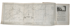
CHABERT, JOSEPH BERNARD de.
Voyage fait par Ordre du Roi en 1750 et 1751, dans l'Amérique septentrionale, pour rectifier les Cartes des Côtes de l'Academie, de l'Isle Royale & de l'Isle de Terreneuve Et pour en fixer les principaux points par des Observations Astronomiques.
Paris, L'Imprimerie Royale, 1753. 4to. Contemp. full motteld calf. Raised bands, richly gilt spine and with gilt lettering. Stamp on title-page. (2),VIII,288,(10) pp., 8 folded engraved maps and charts, 1 engraved vignette, 1 folded plate and 1 folded table. Internally clean, a few marginal brownspots.
Reference : 54164
First edition. The work is in two parts the first is an abridgement of his journal accompanied by charts" the second is devoted to his astronomical observations. It contained the most accurate hydrographic survey of the east coast that had yet been made, and the Ministry of Marine subsidized publication by taking 200 copies for its own use.Chabert marked himself out as a chef d'escadre during French involvement in the American War of Independence and was promoted to vice admiral in 1792. He was known above all for his scientific endeavours, notably in the rectification of naval charts of America's western coast and the coasts of the Mediterranean. He entered the Académie des Sciences in 1758 and the Bureau des Longitudes in 1803. In 1785, he was elected a foreign member of the Royal Swedish Academy of Sciences.""Mr. Chabert's work is highly praised by the commission by the French Academy of Science to examine it, and it is recommended as a model to future navigators...."" (Sabin).Sabin, 11723.
Bookseller's contact details
Herman H. J. Lynge & Son
William Schneider
Silkegade 11
1113 Copenhagen
Denmark
+45 33 155 335
Payment mode
Sale conditions
All items may be returned for a full refund for any reason within 14 days of receipt.
 Write to the booksellers


