OWEN, W.F.W.
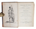
Narrative of Voyages to explore the Shores of Africa, Arabia, and Madagascar performed in H.M. Ships Leven and Barracouta, under the Direction of Captain W.F.W. Owen. 2 Vols.
London, Richard Bentley, 1833. 2 contemp. hcalf. Richly gilt spines. Gilt lettering. Very light wear to top of spines with a small repair. 2 engraved frontispieces. XV,(1),434"VIII,420 pp., Errat-slip bound in. 3 engraved plates and 4 large folded engraved maps. Plates with some marginal brownspots, otherwise clean and fine.
Reference : 54086
First edition. ""Owen mapped the entire east African coast from the Cape to the Horn of Africa between 1821 and 1826 in the sloop Leven and in company with the brig Barracouta. During this period, Owen established a one-man protectorate of Mombasa with the aim of disrupting the 'hellish trade' in slaves"" but Owen was forced to shut down under orders from the Crown after only three years. When he returned in 1826, with 300 new charts, covering some 30,000 miles of coastline, over half of his original crew had been killed by tropical diseases.""
Bookseller's contact details
Herman H. J. Lynge & Son
William Schneider
Silkegade 11
1113 Copenhagen
Denmark
+45 33 155 335
Payment mode
Sale conditions
All items may be returned for a full refund for any reason within 14 days of receipt.
 Write to the booksellers


