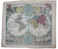
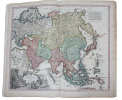
"HOMANN, JOHANN BAPTIST.
Atlas Minor L. Selectorum Tabularum Homanni. Kleiner Atlas von Fünffzig Auserlesenen Homanns=Land=Karten, Nach Anleitung der neuesten Erd=Beschreibere, verbessert und eingerichtet...(= Printed title) - (Engraved title:) Atlas Novus Terrarum Orbis Impe... - [AN EARLY COMPLETE HOMANN-ATLAS]
Nürnberg, Homannischen Officin, n.date (maps ca 1720-39). Large folio. 54,5x32 cm. Contemporary, probably original, limp full calf with flap (""portmanteau""). (Only 4 maps with dating: 2 with 1732, 1728 and 1739).Cover with blind-tooled frames inside which a crowned monogram and the number 50 (= number of plates). Binding worn at edges, covers and back somewhat rubbed. Flap torn and partly with an old repair. Fine allegorical engraved hand-coloured title, printed title with Index (these 2 leaves strengthened in lower margin, no loss of image), and all 49 engraved maps, all in fine original hand-colouring and in double-folio. In excellent condition, with large cartouches (cartouches uncoloured). A few maps with insignificant small tears in folding. The title-page engraved by Michael Rössler, pointing to an early issue of the atlas, and before the publishing house had its name changed to Homann Erben (from 1730).
Reference : 51181
A fine, complete and early atlas from the famous Nürnberger map-maker and publisher, J.B. Homann, geographer to the Kaiser (Emperor). The atlas comprises: Engraved Title. The hemispheres. Europe. Asia. Africa. America. Spain & Portugal. France (Galliæ). England. Holland & Belgium. Belgia etc.. Holland. Schweitz. Italy. Savoye. Milano etc.. Florenz. Naples. Sicily. Germany. Austria. German Provinces 18 maps. Slesvig. Holstein. Scandinavia. Denmark. Sweden & Finland. Poland. Preussen. Russia. Hungary & Greece. Palestine.
Bookseller's contact details
Herman H. J. Lynge & Son
William Schneider
Silkegade 11
1113 Copenhagen
Denmark
+45 33 155 335
Payment mode
Sale conditions
All items may be returned for a full refund for any reason within 14 days of receipt.
 Write to the booksellers


